Cruise port · Chile · South America
Puerto Montt cruise port guide
Puerto Montt is a working port city in Chile's Lake District, and the gateway to snow-capped volcanoes, deep blue lakes and German-influenced towns. Ships anchor in the Reloncaví Sound and tender passengers ashore, and most visitors head out to Lake Llanquihue, the Petrohué waterfalls below Osorno volcano, and the lakeside towns of Puerto Varas and Frutillar.
- Volcanoes
- Lakes
- Nature
- German heritage towns
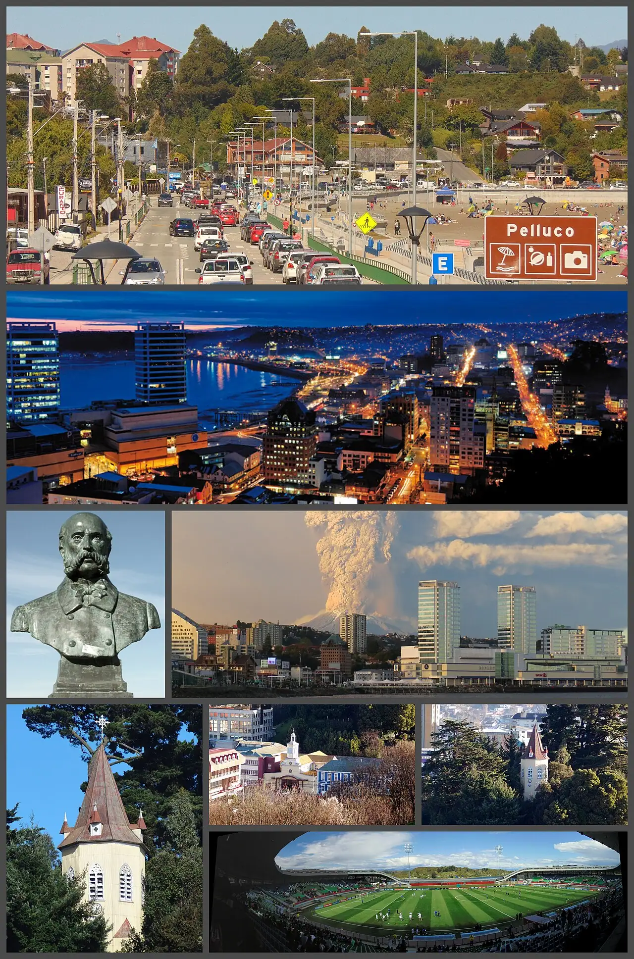
Photo: Montaje realizado por Wikiedro ., CC BY-SA 4.0, via Wikimedia Commons
- Country
- Chile
- Region
- South America
- Type of stop
- Cruise port
- Language
- Spanish. Expect English from tour guides; elsewhere a few Spanish phrases go a long way.
- Currency
- Chilean peso (CLP). Cards are widely accepted; carry cash for markets.
- Best time to visit
- January–December
- Average highs
- 50–71°F through the year
About Puerto Montt
Puerto Montt itself is a practical, rather unglamorous city of fishing boats and salmon farms, but the scenery within an hour is some of the finest in South America. The cone of Osorno volcano rises above Lake Llanquihue, rivers rush through ancient forest, and towns settled by German immigrants in the 19th century have wooden churches, gardens and pastry shops.
The classic port day is a tour to Puerto Varas, the Petrohué Falls in Vicente Pérez Rosales National Park and Lake Todos los Santos, with a stop for kuchen along the way. Closer to the pier, the Angelmó market and fishing harbor are good for seafood and handicrafts.
It's perfect for nature lovers and photographers. The weather is famously changeable, and clouds can hide the volcanoes, so go prepared for rain. If you only want to stroll from the ship, Puerto Montt offers less.
Where cruise ships dock in Puerto Montt
Puerto Montt is a tender port for most cruise ships. Ships anchor in the sound off the city and tender passengers to a landing near downtown. From there, the waterfront and center are a short walk, and the Angelmó fishing harbor and craft market are about 1.5 miles (2.5 km) west, reachable on foot along the waterfront or by taxi. Puerto Varas is about 20 to 30 minutes north by road, and the Petrohué Falls roughly 1.5 hours. Tours and taxis wait near the landing. Weather and swell occasionally affect tendering.
Best things to do in Puerto Montt on a cruise
- 1
Petrohué Falls and Osorno volcano
nature
In Vicente Pérez Rosales National Park, the Petrohué River surges over black volcanic rock, with Osorno volcano rising behind on clear days. Short trails lead to viewpoints. Many tours continue to the emerald waters of Lake Todos los Santos.
- 2
Puerto Varas
culture
This lakeside town on Lake Llanquihue has German-style wooden houses, a waterfront promenade with views of Osorno, rose gardens and the striking red Sacred Heart church. Cafés serve kuchen and coffee.
- 3
Frutillar and Teatro del Lago
culture
Another lakeside town settled by German immigrants, Frutillar is known for its colonial museum and the modern Teatro del Lago, a performing arts center built over the water. It's a charming, quieter alternative to Puerto Varas.
- 4
Angelmó market and fishing harbor
food
Near the city center, Angelmó's waterfront stalls sell woolen sweaters, crafts and souvenirs, while upstairs eateries serve seafood fresh from the boats. Sea lions often gather near the fish stands.
- 5
Lake Todos los Santos boat trip
scenery
Boats cruise this glacial lake surrounded by forested slopes and volcanoes, offering views of Osorno, Puntiagudo and Tronador peaks when skies are clear.
- 6
Chiloé Island day trip
history
Some tours cross to Chiloé, known for its wooden churches, several of them UNESCO-listed, and colorful palafitos, houses built on stilts over the water. It's a long day including a ferry crossing, so check timing carefully.
Puerto Montt weather by month
| Month | Jan | Feb | Mar | Apr | May | Jun | Jul | Aug | Sep | Oct | Nov | Dec |
|---|---|---|---|---|---|---|---|---|---|---|---|---|
| High °F (°C) | 7021 | 7122 | 6720 | 6217 | 5614 | 5111 | 5010 | 5211 | 5513 | 5815 | 6317 | 6720 |
| Low °F (°C) | 5111 | 5211 | 4910 | 478 | 447 | 415 | 405 | 415 | 425 | 447 | 478 | 4910 |
| Rain in (mm) | 0.923 | 1.128 | 1.846 | 3.588 | 4.1104 | 5.4138 | 4.9124 | 4.8121 | 2.666 | 2.460 | 2.153 | 1.435 |
| Daylight (hrs) | 15 | 14 | 13 | 11 | 10 | 9 | 10 | 11 | 12 | 13 | 15 | 15 |
What to eat and drink in Puerto Montt
Try curanto, a feast of shellfish, meat, potatoes and dumplings traditionally cooked in an earth pit on Chiloé, and sold in pot-cooked versions at Angelmó. Mussels, clams and salmon are local staples, and seafood empanadas are a great snack. German heritage shows up in kuchen, fruit tarts often made with local berries. Wash it down with a pisco sour.
Tips for your port day
- Bring rain gear and warm layers; Lake District weather changes quickly.
- Choose a tour with flexible stops so you can still enjoy the falls if clouds hide the volcanoes.
- Carry Chilean pesos for market stalls, though cards are widely accepted elsewhere.
- Watch for tender schedules and allow extra time to return from inland tours.
- Wear sturdy shoes for trails around the Petrohué Falls.
Cruise lines that visit Puerto Montt
Often on the same itinerary
Puerto Montt cruise FAQs
Is Puerto Montt a tender port?
Usually, yes. Most ships anchor in the Reloncaví Sound and tender passengers to a landing near downtown.
How far is Puerto Varas from the Puerto Montt cruise port?
About 20 to 30 minutes by road. It's one of the most popular stops on tours from the ship.
What is the best excursion from Puerto Montt?
A tour to the Petrohué Falls and Lake Todos los Santos, with a stop in Puerto Varas, is the classic choice for volcano and lake scenery.
Can you see Osorno volcano from Puerto Montt?
On clear days, yes, especially from Puerto Varas and Lake Llanquihue. Clouds often hide it, so luck plays a part.
Is Puerto Montt safe for cruise passengers?
Generally, yes. Watch your belongings in busy spots such as Angelmó, and see the U.S. State Department's Chile page for current advice.
Updated November 2026 by the BookMyDreamCruise editorial team. How we research and fact-check.
Sources: Wikipedia, Wikidata, NASA POWER climate data.