Cruise port · New Zealand · Australia & New Zealand
Bay of Islands cruise port guide
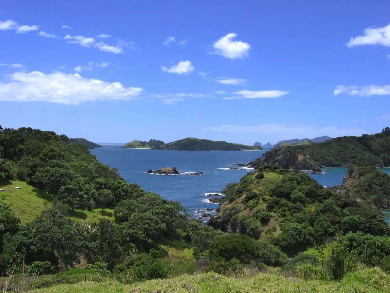
The Bay of Islands, in New Zealand’s subtropical Northland, is a sheltered bay of more than 140 islands and the birthplace of the nation at the Waitangi Treaty Grounds. Ships anchor in the bay and tender passengers to Waitangi or Paihia. Top picks are Waitangi, historic Russell across the water and a boat trip to the Hole in the Rock.
- New Zealand history
- Māori culture
- Boat trips
- Scenic bays
Photo: Fuadounet, CC BY-SA 2.0, via Wikimedia Commons
- Country
- New Zealand
- Region
- Australia & New Zealand
- Type of stop
- Cruise port
- Language
- English and te reo Māori are official languages; English is universal.
- Currency
- New Zealand dollar (NZD). Contactless cards are widely accepted.
- Best time to visit
- January–December
- Average highs
- 60–72°F through the year
About Bay of Islands
This is where modern New Zealand began. In 1840, Māori chiefs and representatives of the British Crown signed the Treaty of Waitangi here, and the Treaty Grounds remain the country’s most significant historic site. Across the bay, Russell was the first permanent European settlement and once a rowdy whaling port.
On a port day, most cruisers visit Waitangi, take the short ferry to Russell, or head out on the water to see dolphins, islands and the Hole in the Rock. It’s a gentle, scenic stop with beaches, walks and history. As a tender port in an open bay, weather can occasionally disrupt the call.
Where cruise ships dock in Bay of Islands
The Bay of Islands is a tender port. Ships anchor in the bay, and tenders usually land at Waitangi or Paihia. The Waitangi Treaty Grounds are a short walk or shuttle from the Waitangi landing, and Paihia’s waterfront is about 1.5 miles (2 km) away. Passenger ferries cross from Paihia to Russell in about 15 minutes. Kerikeri is about 25 minutes by road. Cape Reinga and Ninety Mile Beach are too far for most port days.
Best things to do in Bay of Islands on a cruise
- 1
Waitangi Treaty Grounds
history
See the Treaty House, the carved meeting house Te Whare Rūnanga and one of the world’s largest ceremonial war canoes. The Museum of Waitangi explains the treaty and its ongoing significance. Guided tours and a cultural performance give rich context. Plan on two to three hours or more.
- 2
Russell (Kororāreka)
history
A short ferry ride from Paihia, Russell has a charming waterfront, Christ Church, New Zealand’s oldest surviving church, and Pompallier Mission, a historic printing house and tannery. Walk up to Flagstaff Hill for views.
- 3
Hole in the Rock cruise
scenery
Boat trips head out to Cape Brett and the Hole in the Rock (Motukōkako), a dramatic rock arch boats can pass through in calm seas. Dolphins are often seen along the way. Swimming with dolphins is no longer permitted in the bay, but watching them is a highlight.
- 4
Urupukapuka Island
nature
The largest island in the bay has walking trails, archaeological sites and quiet beaches, reached by ferry. It’s a relaxed escape for walkers and swimmers.
- 5
Haruru Falls walk
nature
A walking track from Waitangi follows the river and a mangrove boardwalk to the horseshoe-shaped Haruru Falls. It’s a pleasant few hours on foot, or a short drive.
- 6
Kerikeri
history
About 25 minutes away, Kerikeri has the Stone Store, New Zealand’s oldest stone building, and Kemp House, its oldest surviving building, beside the river basin. The area is known for orchards and craft shops.
Bay of Islands weather by month
| Month | Jan | Feb | Mar | Apr | May | Jun | Jul | Aug | Sep | Oct | Nov | Dec |
|---|---|---|---|---|---|---|---|---|---|---|---|---|
| High °F (°C) | 7122 | 7222 | 7122 | 6920 | 6519 | 6217 | 6116 | 6016 | 6116 | 6317 | 6519 | 6921 |
| Low °F (°C) | 6720 | 6920 | 6720 | 6518 | 6217 | 5915 | 5814 | 5714 | 5714 | 5915 | 6116 | 6518 |
| Rain in (mm) | 3.588 | 3.077 | 3.384 | 3.590 | 4.2107 | 4.9124 | 5.0126 | 5.0128 | 4.0102 | 3.281 | 3.896 | 2.871 |
| Daylight (hrs) | 14 | 13 | 12 | 11 | 10 | 10 | 10 | 11 | 12 | 13 | 14 | 15 |
What to eat and drink in Bay of Islands
Try fresh fish and chips in Paihia, green-lipped mussels and local oysters. Kūmara (sweet potato) appears on many menus. A hāngī, a traditional Māori earth-oven feast, is sometimes offered with cultural experiences. Finish with pavlova or hokey pokey ice cream, and pair with a Northland wine or New Zealand craft beer.
Tips for your port day
- Weather can affect tendering in the bay; be flexible.
- Don’t bring food ashore; New Zealand’s biosecurity rules are strict.
- Book Waitangi tours and boat trips early.
- Bring sunscreen and a hat; the New Zealand sun is strong.
- Ferries between Paihia and Russell run often, but check the last one back against your final tender time.
Cruise lines that visit Bay of Islands
Often on the same itinerary
Bay of Islands cruise FAQs
Is Bay of Islands a tender port?
Yes. Ships anchor in the bay, and tenders land at Waitangi or Paihia. Weather can occasionally affect tendering.
What is the Waitangi Treaty Grounds?
The site where the Treaty of Waitangi was signed in 1840 between Māori chiefs and the British Crown. It’s New Zealand’s most important historic site.
How do you get to Russell from the cruise ship?
Take a passenger ferry from Paihia, about 15 minutes across the bay.
Is the Bay of Islands worth it on a New Zealand cruise?
Yes. It pairs the country’s most important historic site at Waitangi with sheltered islands, beaches and boat trips, all at a relaxed pace. It’s a gentle introduction to New Zealand’s landscapes and Māori culture.
Can you swim with dolphins in the Bay of Islands?
No. Swimming with dolphins is no longer permitted here, but boat trips often spot them.
Do I need an NZeTA for a cruise to the Bay of Islands?
Yes. Cruise passengers who don’t hold a New Zealand or Australian passport need a New Zealand Electronic Travel Authority (NZeTA) before arriving, and North Americans also pay a visitor levy with it. Apply through the official app or website well before you sail.
Updated November 2026 by the BookMyDreamCruise editorial team. How we research and fact-check.
Sources: Wikipedia, Wikidata, NASA POWER climate data.