Cruise port · New Zealand · Australia & New Zealand
Tauranga cruise port guide
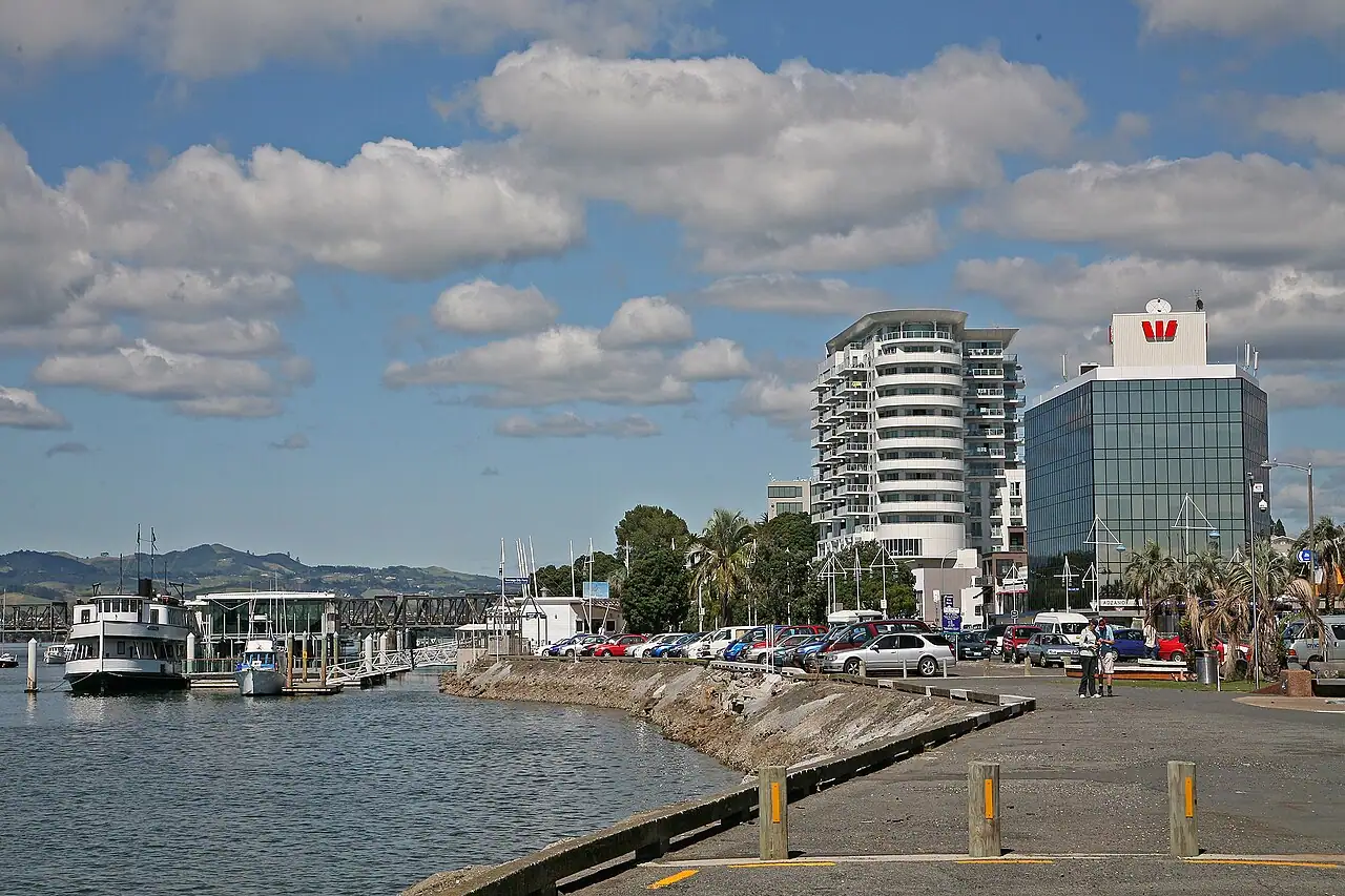
Tauranga, on New Zealand’s North Island, is the cruise port for Rotorua’s geysers, bubbling mud and Māori culture, about an hour inland. Ships dock at Mount Maunganui, a beach town at the foot of an extinct volcanic cone, so you can also stay close and hike the Mount, swim at Main Beach or soak in hot saltwater pools.
- Geysers and geothermal parks
- Māori culture
- Beaches
- Hobbiton
Photo: W. Bulach, CC BY-SA 4.0, via Wikimedia Commons
- Country
- New Zealand
- Region
- Australia & New Zealand
- Type of stop
- Cruise port
- Language
- English and te reo Māori are official languages; English is universal.
- Currency
- New Zealand dollar (NZD). Contactless cards are widely accepted.
- Best time to visit
- January–December
- Average highs
- 58–73°F through the year
About Tauranga
Mount Maunganui, or the Mount, is a popular holiday town with a long surf beach, cafés and the 760-foot (232 m) volcanic cone of Mauao rising above the port. Tauranga city, across the harbor, is in the heart of the Bay of Plenty, known for kiwifruit orchards and sunshine.
Most cruisers take a tour to Rotorua for geothermal parks and Māori cultural experiences, or to Hobbiton in Matamata. Those who stay close often climb Mauao, swim and relax. It suits both active travelers and beach-goers. Rotorua’s sulfur smell can be strong, and popular tours like Hobbiton need advance booking.
Where cruise ships dock in Tauranga
Ships dock at the Port of Tauranga in Mount Maunganui, a 5- to 10-minute walk from the town center, Main Beach and the base of Mauao. Tauranga city is about 15 to 20 minutes by road across the harbor bridge. Rotorua is about an hour each way, Hobbiton about an hour, and Te Puke’s kiwifruit orchards about 25 minutes. Mount Maunganui is very walkable, so you can enjoy a full day without transport.
Best things to do in Tauranga on a cruise
- 1
Te Puia, Rotorua
culture
A geothermal valley with the Pōhutu Geyser, one of the largest active geysers in the Southern Hemisphere, plus boiling mud pools, a kiwi house and the New Zealand Māori Arts and Crafts Institute, where carvers and weavers work. Cultural performances are often included.
- 2
Wai-O-Tapu Thermal Wonderland
nature
About 30 minutes south of Rotorua, Wai-O-Tapu has colorful geothermal features, including the orange-rimmed Champagne Pool, the lime-green Devil’s Bath and bubbling mud pools. Walking trails loop through the park.
- 3
Mauao (Mount Maunganui)
nature
The summit track climbs about 760 feet (232 m) in roughly 45 minutes, with panoramic views of the coast, harbor and port. A flat base track circles the mountain. Wear good shoes and bring water.
- 4
Main Beach and Mount Hot Pools
beach
Main Beach is a long surf beach popular with swimmers and surfers; swim between the flags. At the foot of Mauao, Mount Hot Pools offers heated saltwater pools for a relaxing soak.
- 5
Hobbiton Movie Set
culture
The Shire set from The Lord of the Rings and The Hobbit films, near Matamata, about an hour away. Guided tours wander hobbit holes, gardens and the Green Dragon Inn. Book well ahead; tours sell out.
- 6
Redwoods Treewalk, Rotorua
adventure
A walkway of suspended bridges among towering California redwoods in Rotorua’s Whakarewarewa Forest. It’s beautiful by day and lit with lanterns at night.
- 7
Kiwifruit orchard tour
food
Te Puke, about 25 minutes away, is New Zealand’s kiwifruit heartland. Orchard tours explain how kiwifruit are grown and include tastings.
Tauranga weather by month
| Month | Jan | Feb | Mar | Apr | May | Jun | Jul | Aug | Sep | Oct | Nov | Dec |
|---|---|---|---|---|---|---|---|---|---|---|---|---|
| High °F (°C) | 7323 | 7323 | 7122 | 6820 | 6317 | 5915 | 5814 | 5814 | 6016 | 6317 | 6719 | 7122 |
| Low °F (°C) | 6518 | 6519 | 6317 | 6016 | 5714 | 5412 | 5111 | 5111 | 5211 | 5513 | 5814 | 6217 |
| Rain in (mm) | 3.692 | 3.999 | 3.999 | 4.3108 | 5.0127 | 5.6142 | 6.2157 | 4.6116 | 5.5139 | 3.589 | 3.588 | 3.692 |
| Daylight (hrs) | 15 | 14 | 12 | 11 | 10 | 10 | 10 | 11 | 12 | 13 | 14 | 15 |
What to eat and drink in Tauranga
Kiwifruit is everywhere, from fresh fruit to smoothies and wine. Try a hāngī in Rotorua, fish and chips at the Mount, New Zealand lamb and green-lipped mussels. Flat whites, pavlova and hokey pokey ice cream are local favorites. The Mount’s main street has many cafés and restaurants.
Tips for your port day
- Book Hobbiton and Rotorua tours early; they fill quickly.
- Climb Mauao early to avoid heat and crowds.
- Rotorua smells of sulfur; it fades quickly.
- Leave ship snacks and fruit on board; lines ask passengers not to carry food ashore in New Zealand.
- Rotorua tours spend a good part of the day on the road, so choose one built around a single geothermal park rather than three.
Cruise lines that visit Tauranga
Often on the same itinerary
Tauranga cruise FAQs
How far is Rotorua from Tauranga cruise port?
About an hour each way by road. Tours usually combine geothermal parks and Māori cultural experiences.
Can you walk from the Tauranga cruise port to the beach?
Yes. Mount Maunganui’s Main Beach and town center are a 5- to 10-minute walk.
Can you visit Hobbiton from Tauranga?
Yes. It’s about an hour away. Book well in advance, as tours sell out.
Should I choose Rotorua or Hobbiton from Tauranga?
Pick by interest. Rotorua offers geysers, mud pools and Māori culture; Hobbiton is the pick for Tolkien fans. Both are about an hour away, so doing both in one call is a rush.
How long does it take to climb Mount Maunganui?
About 45 minutes to the summit for most walkers, with a steep but well-maintained track.
Is Mount Maunganui worth it without a tour?
Yes. You can climb or circle Mauao, swim at Main Beach, soak in the hot pools and eat along the main street, all on foot from the ship.
Updated November 2026 by the BookMyDreamCruise editorial team. How we research and fact-check.
Sources: Wikipedia, Wikidata, NASA POWER climate data.